


May 14, 2025, Post 2: Geotubing – A Breakthrough in Coastal Erosion Control |High Quality Mains Essay | Prelims MCQs
Geotubing – A Breakthrough in Coastal Erosion Control
NATIONAL HERO — PETAL 002
Date: May 14, 2025
Thematic Focus: Disaster Management, Environment, Innovation
🌊 Intro Whisper
Where waves once devoured the shore, a woven wall now whispers resistance. From the coasts of Kerala rises a silent guardian — a fabric filled not just with sand, but with hope.
🧱 Key Highlights
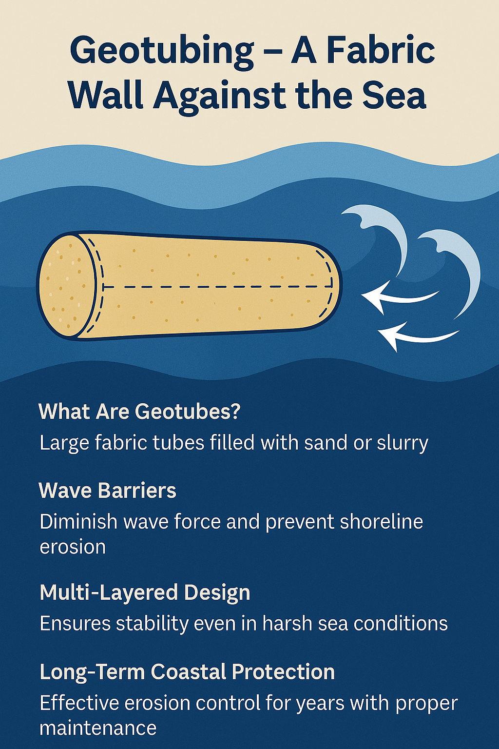
- Geotubing technology is proving successful at Poonthura, Kerala, in resisting coastal erosion.
- Geotubes: Large synthetic fabric tubes filled with sand or slurry, used to dissipate wave energy.
- Multi-layered design ensures durability and long-term shoreline stability.
- Deployed as part of a pilot innovation in erosion mitigation, building upon remote sensing data and community demand.
- Geotubing is cost-effective and adaptable to different coastal conditions.
🔍 Concept Explainer: Coastal Erosion in India & the Engineering Turnaround
India’s 11,098.81 km coastline (revised from 7,516.6 km) spans 9 coastal states and 2 UTs, including 66 coastal districts.
According to National Centre for Coastal Research (NCCR):
- 33.6% of India’s shoreline is actively eroding
- 26.9% shows accretion
- 39.6% remains stable
Worst-Affected States:
- West Bengal – 60.5% erosion
- Kerala – 46.4%
- Tamil Nadu – 42.7%
Major Causes of Coastal Erosion:
- 🌊 Sea-level rise due to climate change
- 🌀 Cyclones and storm surges
- 🚧 Human activity like sand mining and port development
- 🌱 Loss of natural barriers like mangroves and reefs
Geo-engineering Innovations:
- ✅ Geotubes at Poonthura (Kerala), Pentha (Odisha)
- 🪨 Artificial reefs & eco-breakwaters
- 🌿 Mangrove & shelterbelt plantations
🛡️ Government Measures & Policy Interventions
- Integrated Coastal Zone Management Project (ICZMP) – World Bank-funded protection & livelihood mission
- Coastal Regulation Zone (CRZ) Notification, 2019 – Defines NDZs and enforces sustainable shoreline development
- Coastal Vulnerability Index (CVI) by INCOIS – Identifies and maps risk-prone regions
- ₹2,500 crore allocation under 15th Finance Commission for resettlement and mitigation
- National Shoreline Change Assessment offers geo-tagged erosion control guidelines
🧭 GS Paper Mapping
- GS Paper 1: Geography – Coastal morphology, climate impact
- GS Paper 2: Governance – Environmental legislation & policy
- GS Paper 3: Disaster Management, Infrastructure, Innovation in erosion control
- Essay Paper: Man vs. Nature – Reclaiming Shorelines with Science
💫 A Thought Spark — by IAS Monk
“The sea does not retreat because we command it. But we can, with knowledge and care, weave the earth a shield that lets life flourish by its side.”
High Quality Mains Essay For Practice :
Word Limit 1000-1200
Guarding the Edge: The Geological, Ecological, and Human Significance of Coastal Protection
Introduction: Where Earth Meets the Eternal
The sea coast is not merely the end of the land. It is the beginning of interaction—between rock and tide, between time and turbulence, between humanity and its planetary home. Throughout history, coasts have served as cradles of civilisation, economic lifelines, and ecological buffers. Today, in the face of climate change, rising sea levels, and intensifying storms, the protection of sea coasts has become not only a matter of environmental stewardship but a test of humanity’s foresight and scientific ingenuity.
This essay delves into the geological origins of coastlines, their multi-dimensional importance, the pressures they face, and the urgent need for integrated, sustainable protection.
The Geological History of Coasts: Sculpted by Eons
Coasts are dynamic interfaces shaped over millions of years by tectonic activity, erosion, deposition, and sea-level oscillations.
- The current shape of Earth’s coastlines began forming during the Quaternary Period, particularly over the last 20,000 years since the Last Glacial Maximum.
- As glaciers melted, sea levels rose by over 120 meters, submerging continental shelves and sculpting estuaries, deltas, and bays.
- In India, the east coast (Bay of Bengal) is depositional—broad and flat, formed by river sediments (e.g., Ganga, Mahanadi), while the west coast (Arabian Sea) is erosional—steeper and rockier, with lateritic cliffs and narrow plains.
This historical formation makes coastlines incredibly diverse in morphology—from mudflats and marshes to beaches, rocky shores, and coral islands. But it also means they are inherently unstable, requiring constant adjustment to natural forces.
Why Coastlines Matter: Environmental, Economic, and Social Dimensions
1. Ecological Buffers
- Coasts host estuaries, mangroves, coral reefs, lagoons, and dunes—ecosystems that stabilize climate, support biodiversity, and filter pollution.
- Wetlands and mangroves act as natural shock absorbers, reducing wave intensity and protecting inland areas from storm surges.
2. Cradle of Civilisation and Culture
- Coastal zones have been centres of human settlement, trade, and exploration for over 6,000 years.
- Cities like Mumbai, Chennai, Kolkata, and Kochi evolved from historic maritime hubs.
- Coastal regions are cultural heartlands—rich in traditions, temple architecture, folk art, and cuisine inspired by the sea.
3. Economic Lifelines
- Over 40% of the global population lives within 100 km of the sea.
- Ports, fisheries, tourism, energy infrastructure (like refineries and nuclear plants), and transport corridors concentrate along coasts.
- In India, coastal states contribute significantly to GDP, trade, and employment, especially in fisheries, shipping, and coastal agriculture.
The Rising Threats: Why Protection is Urgent
Despite their value, coasts are under unprecedented assault:
1. Sea-Level Rise and Climate Change
- IPCC predicts sea levels could rise between 0.5 to 1 metre by 2100.
- Thermal expansion, glacial melt, and subsidence threaten low-lying coasts and island nations.
- Even small sea level rise increases erosion, saltwater intrusion, and storm impact.
2. Extreme Weather Events
- Cyclones, tidal surges, and changing monsoon patterns are battering coasts more frequently.
- Events like the 1999 Odisha Super Cyclone and 2021 Cyclone Tauktae displaced thousands and eroded large land tracts.
3. Human Interventions
- Unregulated urban expansion, sand mining, and port construction have disrupted sediment flow and weakened natural barriers.
- Dredging, shoreline armouring, and mangrove clearing have removed vital protective ecosystems.
4. Erosion Hotspots
- According to NCCR, 33.6% of India’s coastline is actively eroding, particularly in West Bengal (60.5%), Kerala (46.4%), and Tamil Nadu (42.7%).
Science and Strategy: Approaches to Coastal Protection
The complexity of coastal systems requires integrated and layered responses:
A. Engineering Solutions
- Geo-tubes: Fabric tubes filled with sand (e.g., Poonthura, Kerala) act as submerged wave barriers.
- Seawalls and Revetments: Structures that deflect or absorb wave energy.
- Artificial Reefs: Break wave energy while supporting biodiversity.
B. Eco-based Solutions
- Mangrove and Shelterbelt Plantations: Bio-shields that stabilise coastlines and nurture marine life.
- Coral Restoration: Re-growing damaged reef systems to dissipate wave force.
- Dune and Wetland Regeneration: Strengthens natural barriers.
C. Policy Frameworks
- Coastal Regulation Zone (CRZ) Rules: Classify coasts into regulated zones to control development.
- Integrated Coastal Zone Management Plan (ICZMP): Aims for holistic development with sustainability.
- Coastal Vulnerability Index (CVI): Maps climate risks to prioritise interventions.
D. Community Engagement
- Fisherfolk and local communities must be at the centre of planning, with traditional knowledge integrated into scientific approaches.
Case Study: Pentha and Poonthura
- Pentha Village (Odisha): Became a model site with successful geo-tube installation after severe erosion events. The barrier helped reclaim land and protected 250 homes.
- Poonthura (Kerala): Recently adopted multi-layer geotubing to great effect. Its success lies in alignment with local geomorphology and continuous community involvement.
These examples underline the importance of location-specific strategies, blending modern engineering with ecological thinking.
Challenges to Overcome
- Funding and Maintenance: Erosion protection is long-term and needs ongoing investment. Structures fail without upkeep.
- Scientific Gaps: More real-time coastal monitoring is needed to track sediment flow and wave patterns.
- Institutional Coordination: Fragmented responsibilities between environment, urban, port, and fisheries departments slow implementation.
- Resettlement and Livelihoods: Coastal protection should not be at the cost of displacing fishing communities or destroying traditional rights.
Conclusion: A Line We Must Not Cross
Coasts are the most visible line between man and nature. As seas rise and storms intensify, that line is under siege. But our response must not be to merely build walls—it must be to restore balance.
True coastal protection is not just about resisting the sea. It is about understanding its rhythms, respecting its power, and reclaiming the harmony we once had with it. It is about geology and governance, technology and tradition, engineering and empathy.
Closing Quote
“The sea is patient. But if we are not careful, it will reclaim everything we once called ours.”
— Anonymous Coastal Farmer, Odisha
Target IAS-26: Daily MCQs :
📌 Prelims Practice MCQs
Topic:
MCQ Type 1 — How many are correct?
Consider the following statements regarding coastal erosion and protection in India:
1)Over 33% of India’s coastline is classified as eroding, according to the National Centre for Coastal Research.
2)Geotubing involves placing large sand-filled tubes along the coast to reduce wave force.
3)India’s coastline length is officially recorded as 7,516.60 km by the Ministry of Environment.
4)West Bengal, Kerala, and Tamil Nadu are among the worst affected states in terms of shoreline erosion.
How many of the above statements are correct?
A)Only two
B)Only three
C)All four
D)Only one
🌀 Didn’t get it? Click here (▸) for the Correct Answer & Explanation
✅ Correct Answer: B) Only three
🧠 Explanation:
•1) ✅ True – As per NCCR data, 33.6% of India’s coastline is eroding.
•2) ✅ True – Geotubing uses sand-filled fabric tubes as wave barriers.
•3) ❌ False – The updated official coastline length is 11,098.81 km, not 7,516.60 km.
•4) ✅ True – These are the most erosion-prone coastal states in India.
MCQ Type 2 — 2-Statement Check
Consider the following statements about India’s coastal regulation framework:
1)The Coastal Regulation Zone (CRZ) 2019 identifies No Development Zones to protect coastal stretches.
2)The Integrated Coastal Zone Management Project (ICZMP) was implemented in all coastal districts of India.
Which of the above statements is/are correct?
A)Only 1 is correct
B)Only 2 is correct
C)Both are correct
D)Neither is correct
🌀 Didn’t get it? Click here (▸) for the Correct Answer & Explanation
✅ Correct Answer: A)Only 1 is correct
🧠 Explanation:
•1) ✅ True – CRZ 2019 classifies areas with No Development Zones to prevent unchecked construction.
•2) ❌ False – ICZMP has been implemented in Gujarat, Odisha, and West Bengal, not across all coastal districts.
MCQ Type 3 — Code-Based Multiple Correct
Which of the following are recognised methods of shoreline protection in India?
1)Geo-tube installations
2)Artificial reefs
3)Mangrove and shelterbelt plantations
4)Nuclear seawall installations
Select the correct code:
A)1, 2 and 3 only
B)2, 3 and 4 only
C)1, 3 and 4 only
D)All four
🌀 Didn’t get it? Click here (▸) for the Correct Answer & Explanation
✅ Correct Answer: A) 1, 2 and 3 only
🧠 Explanation:
•1) ✅ True – Geotubes are deployed in places like Poonthura and Pentha for wave buffering.
•2) ✅ True – Artificial reefs are used to reduce wave energy and support marine life.
•3) ✅ True – Mangroves are key bio-shields against erosion.
•4) ❌ False – “Nuclear seawalls” are not a recognised or eco-friendly erosion control measure.
MCQ Type 4 — Direct Factual
Which organisation developed India’s Coastal Vulnerability Index (CVI)?
A)National Centre for Coastal Research (NCCR)
B)Central Pollution Control Board (CPCB)
C)Indian National Centre for Ocean Information Services (INCOIS)
D)Ministry of Jal Shakti
🌀 Didn’t get it? Click here (▸) for the Correct Answer & Explanation.
✅ Correct Answer: C) Indian National Centre for Ocean Information Services (INCOIS)
🧠 Explanation:
•A) ❌ False – NCCR monitors shoreline changes, not CVI.
•B) ❌ False – CPCB focuses on pollution, not coastal mapping.
•C) ✅ True – INCOIS developed the Coastal Vulnerability Index for risk mapping.
•D) ❌ False – Ministry of Jal Shakti deals with water management, not coastal studies.